
The Royal Victoria Yacht Club
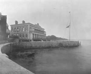
Club house, Royal Victoria Yacht Club
March 2, 1846, was an eventful day for Ryde, for it witnessed no less a ceremony than the laying of the foundation-stone of the Royal Victoria Yacht Club by H.M. Queen Victoria and the Prince Consort. The excellently laid-out town of Ryde had for many years previous to this date been gradually increasing in importance as a fashionable seaside resort during the summer months, and every season saw its houses more occupied and its pier more crowded with fashionable people. It was only natural, therefore, that with the development of yachting as a British sport, Ryde soon became a very popular resort for yachtsmen, and in 1845 it was decided to form a local yacht club there on similar lines to the Royal Yacht Squadron at Cowes. A meeting was held to consider the question, and a set of preliminary rules were passed.
Launched as it was under such brilliant and influential circumstances, it is not surprising that the club rapidly developed into a powerful association, and its ensign being a red one, it soon became known as the ‘Red Squadron.’ The red ensign was distinguished by a crown in the Union Jack as showing its royal title. From its earliest days to the present time it has always set itself particularly for the encouragement of yacht-racing on the largest and most liberal scale. Its first Commodore was Thomas Willing Fleming, a local resident, with Albert J. Hambrough, of Steep Hill Castle, Ventnor, as Vice-Commodore; and in 1859 George Harold Ackers hoisted the Commodore’s flag on the Brilliant. Mr. Ackers was the well-known yachtsman and inventor of Ackers’ time-scales for racing, which were generally used until the advent, many years later, of the Yacht Racing Association, whose time-scale then became universally used. One of the first acts of the club was to offer a reward for the best code of signals suitable for use with yachts, and here again the Commodore’s ingenuity was apparent, for the Ackers set of signal-flags was not only adopted by this club, but also by many others, till the international code of signals replaced it.
Its present flag-officers are : Commodore, Mr. W. B. Paget (yacht Madrigal ); Vice-Commodore, Colonel Bagot (yacht Creole ); and Rear-Commodore, the Marquis of Exeter.
- + 44 (0)1983 717435
- [email protected]
- Tue - Sat : 10:30 - 16:00 Last entry 15:15
Historic Ryde Society
‘Giving Ryde’s Past to the Future’
Photograph Galleries
These Galleries contain engravings and photographs from early days to modern times. Some of the images are very rare and Historic Ryde Society has been given permission by the owners to display them on the website. We may allow others to use some of these images, but please do us the courtesy of requesting permission first.
Please read our copyright notice. All images are covered by copyright laws.
RYDE DISTRICT HERITAGE CENTRE
NEWSPAPERS & ADVERTISMENTS
PHOTOGRAPHS & POSTCARDS
ROYALS IN RYDE
RYDE TREASURES
RYDE BUILDINGS
Site Map | HOME | Latest News | Calendar | Museum of Ryde | Historic Ryde Society | Donald McGill | Photo Gallery | Join | CONTACT

Royal Victoria Arcade Union Steet Ryde Isle of Wight PO33 2LQ
Registered Charity No. 1173957 Tue-Sat: 10:30-16:00 Last entry: 15:15
- Tue - Sat : 10:30 - 16:00
- Last entry 15:15
© 2022 All content is copyrighted to the Historic Ryde Society and its contributors
Accessibility | Copyright | Disclaimer | Privacy
- ☰ Menu
- Knowledge Base
Royal Victoria Yacht Club

Royal Victoria Yacht Club 91 Fishbourne Lane Ryde Isle of Wight PO33 4EU United Kingdom
- Website: https://www.rvyc.org.uk

| Office 2 Phone : +44 (0)1983 241615 |

- CLASSIFIEDS
- NEWSLETTERS
- SUBMIT NEWS

Boats for sale
Royal victoria yacht club celebrates 175 years.

Related Articles
Upcoming Events
Royal Victoria Yacht Club
Location & hours.
Suggest an edit

91 Fishbourne Lane
Ryde PO33 4EU
United Kingdom
Recommended Reviews
- 1 star rating Not good
- 2 star rating Could’ve been better
- 3 star rating OK
- 4 star rating Good
- 5 star rating Great
Select your rating
Overall rating
Seemingly a small friendly club etc. But, like a lot of sailing clubs, rather cliquey and Friday evenings are to be avoided, unless you like raucous cadets and their similar parents! Very tidal and mooring is limited to small craft and bilge keelers.
People Also Viewed

royal lymington yacht club
Warsash Sailing Club

Fareham Leisure Centre
Elmore Angling Club

Synergy Sailing

Bosham Sailing Club
Gurnard Sailing Club

The Quays ‘Eddie Read’ Swimming & Diving Complex

St. Paul’s Sports Centre
Other Sports Clubs Nearby
Find more Sports Clubs near Royal Victoria Yacht Club
Lot 47 Freehold Four Storey Waterfront Building With Potential Auction Date: 20th March 2024
The prince consort, st. thomas street, ryde, isle of wight, po33 2dl.

Enjoying a stunning location on the seafront at Ryde, overlooking the Solent, the Prince Consort building was formerly known as the Royal Victoria Yacht Club and was built at a cost of £4,500 and completed in 1847, with the foundation stone having been laid by Prince Albert in the spring of the previous year. Unable to enter the Royal Yacht Squadron at Cowes, which was a male-only establishment, Queen Victoria effectively set up the Royal Victoria Yacht Club as a rival.
The Yacht Club was based in the building until 1966, after which it has had a varied history, having initially traded as a restaurant. In more recent years, the upper two floors have been converted into stunning apartments enjoying wonderful views and the convenience of a town centre location. The lower two floors were last in use as a call centre but have lain vacant for some years.
The freehold of the building is now offered for sale with scope and potential to bring the lower two floors back into meaningful use. Previous, though now lapsed, Planning Permissions were achieved in 2016 for conversion of the ground floors with both residential and commercial options and usage.
Local Planning Authority
Isle of Wight Council. Tel: 01983 823552. Website: iow.gov.uk.
Lapsed Planning
Planning Permission was granted by Isle of Wight Council under ref: P/01130/15, dated 29th April 2016, for proposed internal and external alterations, to include replacement of access gates, to refurbish lower ground floor offices and to convert part of lower ground floor and ground floor to a residential unit (revised scheme) (revised description), subject to conditions.
Planning Permission was granted by Isle of Wight Council under ref: TCPL/24772/P0000705/02 for conversion of the upper ground floor into a single residential unit and refurbishment of ground floor offices, subject to conditions.
These consents were not actioned and have now lapsed.
Accommodation
The lower two floors have most recently been in commercial usage as a call centre and supporting offices but include on the ground floor the grand reception, being the triple-aspect reception room overlooking the Solent, formal reception, state room and a range of smaller rooms, including kitchens, ladies’ and gents’ cloakrooms and ancillary offices. The lower ground floor offers a further range of offices and supporting infrastructure.
First Floor Apartment
Sold on a 999-year lease from 1st December 2005 at a current ground rental of £100 per annum.
Top Floor Penthouse Apartment
Sold on a 999-year lease from 1st December 2001 at a current ground rental of £100 per annum.
Car parking to the front, and walled garden to rear which includes additional car parking accessed via the adjoining car park, subject to a licence arrangement.
Auctioneer’s Note
Vehicular access to the walled garden/car park is subject to a 125 year lease from 14th November 2002, at a current rental of £2,000 per annum.
The freehold is to be offered, with the first floor and penthouse level apartments sold on a long leasehold basis, paying a combined ground rental of £200 per annum and contributing to the management and maintenance of the building.
The map and satellite images are based on postcode information and are available for for directions only. The may not necessarily show the exact lot being offered, but will be in close proximity. Please refer to the sale plan in the legal documentation for precise details of the lot to be sold.
Joint Agents

Seafields 01983 812266
All lots are sold subject to the Common Auction Conditions and Special Conditions of Sale (unless varied by the Sellers Solicitors), together with the Addendum, which will be available on Auction Day.
* Price Information
Guides are provided as an indication of each Seller’s minimum expectation. They are not necessarily figures at which a property will sell for and may change at any time prior to Auction. Unless stated otherwise, each Lot will be offered subject to a reserve (a figure below which the Auctioneer cannot sell the Lot during the Auction).
We expect the reserve will be set within the guide range or no more than 10% above a single figure guide. Please check our website regularly at cliveemson.co.uk, or contact us on 01622 608400 , in order to stay fully informed with the up-to-date information.
Additional Fees
An Administration fee and Other non-optional fees may also be payable in addition to the bid price. All lots are offered subject to the Common Auction Conditions and Special Conditions of Sale or Revised Special Conditions of Sale (as applicable) and may include the repayment of search and other fees and or costs payable by the buyer.
All buyers are advised to inspect all available legal documentation prior to bidding and will be deemed to fully understand what they may be liable for if they are successful in purchasing. This should also include Stamp Duty, Land Registry fees and VAT which may become payable on completion in line with any property transaction, whether it is by auction or private treaty. If, as a buyer, you are in doubt you should seek advice from your own professional advisors. For more information on fees please go to Buyers Fees
Our Accreditations and Associates

© Clive Emson Land & Property Auctioneers. All rights reserved.
Registered office: Rostrum House, Rocky Hill, London Road, Maidstone, Kent, England. ME16 8PY.
Registered company: 02399687, Regional Property Services Ltd. [email protected] 0345 8500333
Royal Victoria Yacht Club
Related Searches
- royal victoria yacht club ryde •
- royal victoria yacht club ryde photos •
- royal victoria yacht club ryde location •
- royal victoria yacht club ryde address •
- Your Privacy Choices
- Bahasa Indonesia
- Los Angeles
- Philadelphia
- San Francisco
- Washington, D.C.
- Great Britain
- Netherlands
- Philippines
- More Great Places in Ryde:
Foursquare © 2024 Lovingly made in NYC, CHI, SEA & LA
You might also like

Costa Coffee
Coffee Shop · £
Ryde Pier Head
"Actually never been in here before. But the view from in here is pretty awesome and worth a visit :)"
Michelangelo
Italian · ££
81 Union St (St Thomas St)
"Try Tagliatelle Al Ragu' Di Mare - delicious pasta with tasty seafood."
French Franks
2 St Thomas Sq
"Very tasty Illy coffee. Also had a panini and cake which were delicious!"
Is this your business? Claim it now.
Make sure your information is up to date. Plus use our free tools to find new customers.
You must enable JavaScript to use foursquare.com
We use the latest and greatest technology available to provide the best possible web experience. Please enable JavaScript in your browser settings to continue.
Download Foursquare for your smart phone and start exploring the world around you!
- ☰ Menu
- Visiting Us
- About the RVYC
- The Club House
- On the Water
- Club Racing
- Open Events
- Youth Dinghy Championships at RVYC
- Merrydown Regatta
Sailing Overview
- 7 Classes & Fleets...
- Fast Handicap
- Slow Handicap
- RVYC Illusion Class
- 2 Powerboats...
- Youth Powerboat Group
- 1 Cadets...
- Cadets at the RVYC 2024
- Adult Sailing
- Dinghy Hire
- Dinghy Park Fees (24/25)
- Travel Reports

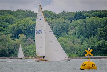
We have an extensive range of on the water activities throughout the year. Some are regular events and others happen annually. From our very active Cadet section, Saturday open sailing, Adult training evenings, a wide range of training opportunities, extensive racing programme and our Cruiser group, we are sure you will find something to help get you on the water.
2024 Programme click here - opens in new tab
Cadets cover the ages 8 to 18, they will generally sail in Optimists, Picos, double handed RS Fevas , Wayfarer or Lasers (ILCA 4,6 & 7 ).
Click here for further information.
SATURDAY OPEN SAILING
Saturday SImply Sailing operates from May until September, for dates and times please see the calendar or click here for filtered list .
The sessions are for club members to get on the water either in their own boats or by hiring club boats.
We provide the RIB cover, you just enjoy the sailing!
ADULT SAILING
As the name implies this is for adults only. If you have never sailed a boat but would like to then these sessions are for you.
Beginners, improvers and those wishing to acquire more specific skills are welcome.
Click here for more information. Dates are in the calendar , or the filtered list is here .
DINGHY HIRE
Details for members to hire dinghies from RVYC can be found here .
TRAINING COURSES
As an RYA approved training centre we run a variety of courses throughout the year. New courses are added as they are arranged.
Both on the water and shore based courses can be run. More details in the training tab .
CLUB RACING
A full programme of competitive club racing is available from the end of March to the end of December.
Starting usually from our race platform to the west of the ferry channel, we provide racing for keelboats and dinghies in handicap series.
We also run a number of open events during the year.
Race dates are in the calendar , or the filtered club racing list is here and the scow racing is here .
CRUISER GROUP
Our cruiser organising group organise events throughout the year. For details see the cruising tab
Last updated 14:24 on 9 August 2024

| 91 Fishbourne Lane Phone : 01983 882325 Tax No. 107847361 |
Nizhnevartovsk Airport
Nizhnevartovsk, khanty-mansiysk autonomous okrug – ugra, russia.
60.949299 60° 56' 57.47" N
76.483597 76° 29' 0.949" E
Facitlity Type
Operational
2024-08-18T15:12:18
2024-08-18T20:12:18+05:00
Asia/Yekaterinburg
We use cookies to improve your user experience and analyze website traffic.
Manage your cookie preferences
You can also change cookie preferences by clicking the "Cookies" link at the bottom of our site.

Share ×

Scan the QR code and open PeakVisor on your phone
❤ Wishlist ×
See all region register, peakvisor app, khanty-mansiysk autonomous okrug – ugra.
Welcome to the land of sheer silent whiteness. Its vast expanses are filled with fresh Arctic air, howling winds, and the spirit of true adventure. Come with us to the lands of the ancient Khanty and Mansi tribes that survived in this harsh climate of the Nether-Polar Urals . See the mountains that defy any logical or geological reason for their existence. Experience the wonders of this sparsely populated land where you can hardly see a human trace. Welcome to Yugra!
Flora & Fauna
Water resources, landmarks and tourism, major mountains, mount narodnaya, mount zaschita, mount neroyka, the pyramid mountain, samarovskaya mountain, ski and sports facilities, protected sites, reserves, national and natural parks, rivers and lakes, major cities, khanty-mansiysk.
The Khanty-Mansiysk Autonomous Area – Yugra (KhMAO) is located in the central part of the West Siberian Plain, stretching from west to east from the Ural Range to the Ob-Yenisei Watershed. The vast areas of this plain, as well as the Lower Priob region, are considered one of the most recently inhabited areas.

The Khanty-Mansiysk Autonomous Area (KhMAO) was established in 1930. Its name comes from two main northern indigenous peoples – the Khanty and the Mansi. From 1944 it was legally part of the Tyumen Region , but in 1993 the Area received autonomy and became a full-fledged territorial entity of the Russian Federation. It is a part of the Urals Federal District. The administrative centre is the city of Khanty-Mansiysk , whereas the largest city is Surgut. The word Yugra was introduced to the name of the Khanty-Mansiysk Autonomous Area in 2003 to pay tribute to the old name used by the locals to call the territories lying beyond the North Urals.
The KhMAO borders the Komi Republic in the north-west, the Yamalo-Nenets Autonomous District in the north, the Krasnoyarsk Area and the Tomsk Region in the east and south-east, the Tyumen Region in the south and the Sverdlovsk Region in the south-west.
The area of the territory is 534,801 sq.km, the length from north to south is 800 km, from west to east is 1400 km. The population of this huge territory is 1,674,676 people as of 2020, which is the same amount as people living in Barcelona or Munich.

The main part of the territory is a huge, poorly dissected plain where absolute elevation marks rarely exceed 200 meters above sea level. The western part of the KhMAO territory is characterized by low and middle mountainous terrains with some Alpine relief featured in the Subpolar Urals. Here are ridges and spurs of the mountain system of the North Urals and the Subpolar Urals. The maximum absolute elevations are on the border with the Komi Republic . Mount Narodnaya (1,895m) is the highest peak.
More than 800 species of higher plants grow in the Khanty-Mansi Autonomous Area . Almost the entire territory is covered by taiga forests that occupy about 52% of the area. Spruce, fir, pine, cedar, larch, birch, alder grow here. In the northern parts of the area, the composition of the vegetation is greatly influenced by perennial permafrost. Light lichen grasslands which are used as deer pastures are widespread there. Tundra dominates in the mountainous and hilly areas. River floodplains and lowlands are characterized by meadow vegetation, the so-called water meadows. High floodplains of large rivers are mainly covered with woods that mainly feature willows, birches and aspens. Forests and swamps are rich in berries and various valuable plants, most of which are used in traditional indigenous medicine.

The animal world is typical for the Russian taiga zone. There are 369 species of vertebrates. Mammals are represented by 60 species (28 of them are commercial species). The most common and valuable of them are wild reindeer, elk, fox, sable, fox, squirrel, marten, ermine, Siberian weasel, polecat, mink, weasel, otter, hare and others. Wolverine and West Siberian river beaver are included in the Red Book of Russia.
There are 256 bird species in the region, including 206 sedentary and nesting species. Some rare bird species are listed in the Red Book. There are 42 species of fish in rivers and lakes. Of these, 19 species are commercial, among them are starlet sturgeon, lelema, muksun (whitefish), pelyad, chir, lake herring, wader, tugun, freshwater cod, pike, ide, roach, bream, fir, perch, ruff, golden and silver crucian carp, carp (carp is grown in the cooling ponds of the Surgutskaya and Nizhnevartovskaya hydroelectric plants). Sturgeon is listed in the Red Book. There is an abundance of mosquitoes and gnats in the area, the greatest activity of which is in the second half of summer.

Yugra can boast of over 2 thousand large and small rivers, the total length of which is 172,000 km. The main rivers are the Ob (3,650 km), the Irtysh (3,580 km). These are some of the largest rivers in Russia. Other significant rivers include the tributaries of the Ob (the Vakh, Agan, Tromyogan, Bolshoy Yugan, Lyamin, Pim, Bolshoy Salym, Nazym, Severnaya Sosva, Kazym rivers), the tributary of the Irtysh (the Konda River) and the Sogom River. Ten rivers are over 500 km long. All the Yugra rivers with the exception of the rivers in the Ural part of the region are characterized by rather slow currents, gentle slopes, some surge wave phenomena, spring and summer floods. The Ob River basin extends over a distance of 700-200 km from the mouths of its tributaries. Such abundance of water facilitates the appearance of floodplain swamps and seasonal lakes.
The region's swamps are predominantly of the upper and transitional type. Those water basins occupy about a third of the region. About 290,000 lakes with the area of more than 1 ha are surrounded by swamps and forests. The largest lakes are Tursuntsky Tuman, Levushinsky Tuman, Vandemtor and Trmemtor. The deepest lakes are Kintus (48 m) and Syrky Sor (42 m). However, most of the lakes (about 90%) are modest and quite small and have no surface runoff.
The area is rich in resources of fresh, mineral and thermal underground waters, which are still insignificantly used.

The climate is moderately continental. Winters are harsh, snowy and long, and summers are short and relatively warm. The territory is protected from the west by the Ural Mountains but its openness from the north has a significant impact on the climate formation because cold air masses from the Arctic freely penetrate the area. The flat character of the terrain with a large number of rivers, lakes and swamps also has its impact. Most of the precipitation falls during the warm seasons. But even with a small amount of precipitation, their evaporation is very low, which as a result contributes to the formation of the zone of excessive moisture throughout the Yugra. The snow cover is stable from late October to early May, its height varies from 50 to 80 cm. The region is characterized by a rapid change of weather conditions, especially in transitional seasons (autumn and spring), as well as during the day. Late spring and early autumn frosts are rather frequent and can happen even until mid-June. Average January temperatures range from -18ºC to -24ºC (0 F to -11 F) and can reach -60ºC to -62ºC (-76 F to -80 F) when the northern cold air masses break through. The average temperature in July, the warmest month of the year, ranges from +15ºC to +20ºC (+59 F to +68 F) and on very rare days can reach a maximum temperature of +36ºC (+97 F). The prevailing wind direction is north in summer and south in winter.
The weather in the mountains is quite changeable and cool even in summer. The best time to visit the region's mountains is between July and mid-August.
The Yugra of the Khanty-Mansi Autonomous Area has a huge natural resource potential. These are oil and gas deposits, forests, gold and iron ore deposits, as well as bauxites, copper, zinc, lead, niobium, tantalum, brown and hard coal deposits, rock crystal, quartz and piezo quartz, peat deposits, etc. The region has plenty of natural resources. In terms of natural gas reserves, the Yugra ranks second in the Russian Federation after the Yamalo-Nenets Autonomous District .
The industry is dominated by oil and gas production, power generation and processing industries, including woodworking except for pulp and paper production.

The Khanty-Mansi area has very developed tourism of all kinds. There is a modern infrastructure for cultural exploration as well as for active recreation.
Fans of sports and eco-friendly tourism will be able to conquer majestic mountains and raft down picturesque rivers, enjoy the beauty of nature in nature reserves and natural parks. The hills and mountains of this area open up endless opportunities for skiing and snowboarding.
The mountainous part of the Subpolar Urals located on the territory of the Khanty-Mansi Autonomous Area is very beautiful. The highest peaks of the Ural Mountains are situated here.
Being the highest point of the whole Urals, Mount Narodnaya (1,895 m), also known as Naroda and Poenurr and translated as People's Mountain is territorially situated in the Subpolar Urals, on the border of the Yugra Area and the Komi Republic . It is the highest point in European Russia outside the Caucasus. This leads to its large topographic prominence of 1,772 metres (5,814 ft).

The top of the mountain is half a kilometre from the border towards Yugra. As for the name of the mountain, scientists could not come to a common opinion for a long time, so there are two versions. According to one version, in the Soviet years, an expedition of pioneers gave the mountain a name in honour of the Soviet people - Narodnaya (the stress is on the second syllable). According to the other version, even before the arrival of the first Soviet tourists, the peak was named after the River Naroda (the stress is on the first syllable) flowing at the foot of the mountain. The Nenets peoples called the River Naroda Naro, which means a thicket or a dense forest, and the Mansi peoples called it Poengurr or Poen-urr, which translates as the top, or head. The maps used to refer to it as Mount Naroda or Mount Naroda-Iz. Nowadays, it appears everywhere as Narodnaya.
In the 1980s, someone set a bust of Lenin on the top of the mountain. Its remains can be found there to this day. There is one more symbolic relic there – some Orthodox believers erected a worship cross on top of Mount Narodnaya after a Procession of the Cross.
The slopes of the mountain are steeper in the north-east and south-west and there are many steep rocks on them. The south-eastern and northern parts of the mountain are more gentle but they are also covered with scree. Be vigilant and careful when climbing! On the slopes of the mountain, there are many not only boulders but also caverns filled with clear water as well as ice. There are glaciers and snowfields. From the north-eastern part of the mountain, you can observe Lake Blue near which tourists and travellers like to make bivouacs.

Mesmerizing with its beauty and inaccessibility, it attracts many tourists and fans of active recreation. This majestic mountain is quite remote from the settlements, so getting to it is not an easy task. The mountain is located in the Yugyd Va National Park , so it is necessary to register in advance and get a visit permit from the park administration. How to get to the park administration and get a permit, read the article on the Yugyd Va National Park .
Mountain Zaschita (1,808 m) is the second-highest peak in the Ural Mountains, after Mount Narodnaya . Mysteriously, the name of the mountain, which roughly translates as Defense or Protection Mount, does not correlate in any way with the Mansi names of the nearby mountains and rivers. The origin of the name is unknown. There are some speculations but we will consider just one of them. On the map of the Northern Urals which was made by the Hungarian researcher Reguli the closest peak to Mount Narodnaya was called gnetying olu. Its location coincides with that of the present-day Mount Zaschita . The name gnetying olu in the Mansi can be deciphered as a mountain on which there is some help from ice. The mountain is believed to protect deer grazing on glaciers from mosquitoes. So, early topographers called the mountain more briefly – Mount Defense. Indeed, the slopes of this mountain are covered with a lot of snow and glaciers (the Yugra, Naroda, Kosyu, Hobyu glaciers and others). And it is here that the Mansi shepherds bring their deer which can rest on glaciers and snow. Summarizing all the above, we can say that Zaschita Mount is to some extent protection for deer from mosquitoes. The very name Zaschita appeared on maps with the beginning of hiking tours in the Subpolar Urals.
Mount Neroyka (1,645 m) is 100 km from Neroyka village, the closest tourist base to this peak. In the 1950s, people who were engaged in quartz mining near the mountain worked and lived in this base. Later, a gravel road was built from the village of Saranpaul to the mountain for large-scale development of the quartz deposit. In recent years, the road has not been much used and is practically not cleaned from snow in winter. There has been a plant built 20 km down from the mountain for primary processing of quartz with the use of nanotechnologies. There is an annual big camping event near the mountain. It is organized by the Tourism Department of the Khanty-Mansi Autonomous Area. You can have a 1-hour helicopter ride to the mountain from the village of Saranpaul. Should you wish to fly from the city of Khanty-Mansiysk , be prepared to fly over the taiga for 2.5-3 hours.

Quite inquisitive tourists happened to discover, by a lucky chance, a Pyramid similar to that of Cheops but four times bigger. It is located on the territory of the Narodo-Ityinsky Ridge. The closest to the pyramid is the village of Saranpaul. The sizes of the found pyramid are as follows: the height is 774 m, in comparison to the Egyptian pyramid which is 147 m; the length of a lateral edge is 230 m whereas the Egyptian pyramid is 1 km. The pyramid is located precisely according to the cardinal directions, there is not a single degree deviation at that. The origin of the pyramid is unknown, scientists are still making assumptions. No traces of human activity were found near the pyramid. The only way to get here at this time is by helicopter.
Samarovskaya Mountain is another wonder that is baffling many people. It is dividing the city of Khanty-Mansiysk into northern and southern parts. Few now living residents know that in the old days the highest part of the modern city used to bear a plural name of the Samarovsky Mountains among which there were Mount Palenina, Komissarskaya, Miroslavskaya, Filinova, and Romanova. Originally, there was a village called Samarovo amidst these mountains. Until now, many issues bewilder both residents and scientists. How could a mountain form in the middle of the West Siberian Plain? What is inside it? Won't the weight of the buildings erected on the top of the mountain affect its height? The uniqueness of Samarovskaya Mountain is that it consists of numerous large stones, boulders, rocks that are absolutely foreign to this area. Scientists have not yet come to a consensus on the mountain’s origin.

The Yugra is very famous for its ski resorts, the main of which are:
- The Cedar Ravine ski resort (Surgut city, Naberezhny Ave. 39/1)
- Three Mountains (Trekhgorie) ski resort (30 km from Nizhnevartovsk, Ermakovsky settlement)
- Stone Cape (Kamenniy Mys) ski resort (near the city of Surgut)
- Pine Urman ski resort ( Khanty-Mansiysk , Sportivnaya Str., 24)
The far-away lands of the Yugra are the blessed sanctuaries for many animals as the area is rather hostile to a human There are reserves, natural parks, wildlife sanctuaries here that aim to protect the national treasures of the lands. Having visited these regions once, you would crave for coming back again and again to feel that unique sense of unity with nature, to forget about the urban fuss and and hustles whatsoever. The harsh but beautiful nature of this extraordinary area leaves an indelible trace in the soul of every person.

On the territory of the district there are 25 specially protected natural areas, the most famous of them are:
- The reserves are two: the Malaya Sosva Reserve and the Yugan Reserve, the latter was established in 1982 as the largest reserve of taiga landscapes. The purpose of the reserves was to study unobtrusively and carefully preserve the endemic flora and fauna without disturbing natural processes. Hunting and economic activities are prohibited here, which is important for the preservation of natural ecosystems.
- The natural parks are the Samarovsky Chugas Nature Park, the Siberian Sloping Hills (Uvaly), the Numto (also called Lake Numto), and the Kondinskie Lakes.
These reserves and natural parks offer tourists their own excursion programs to make visiting their territory much more enjoyable and educational.
The Samarovsky Chugas Nature Park is located in the center of Khanty-Mansiysk , on a small hill between the Ob and Irtysh rivers.
The territory of the Siberian Sloping Hills (Uvaly) natural park is 350 km away from the city of Khanty-Mansiysk . You can get there by helicopter or by plane. The office of the park is located at 7a Pionerskaya Street, Nizhnevartovsk.
The Kondinskie Lakes Natural Park is located 380 km from Khanty-Mansiysk . Half of the park is covered with swamps, but there is also a recreational area. There you can rest, swim, do some amateur fishing, picking berries (cowberries, cranberries) and mushrooms is permitted. There is only one independent walking route here, it runs for 3 km in the deep forest. It is a cool place for kids since the park is equipped with sports grounds, a pool and a small zoo where the kids can interact with brown bear cubs. What else, try the TaiPark, it is a rope course running at the height of 2.5 meters, having 15 stages, the full length is 125 meters. There is an opportunity to order water walking tours in the town of Sovetsky, which can be reached by train from Khanty-Mansiysk .

The Numto Nature Park is located almost in the center of the West Siberian Plain, in the Beloyarsk district of the Khanty-Mansi Autonomous Area, 300 km from the city of Surgut and 200 km from the town of Beloyarsk. It is located on the border of Yugra and Yamalo-Nenets Autonomous Area. The administration of the park is located at 2, Beloyarsky micro-district, 4a. The territory of the natural park is a treasure trove of archaeological and ethnocultural monuments. As of today, there have been discovered 20 architectural monuments, including fortified and not fortified settlements, places of worship abandoned by the peoples who lived here from the Stone Age to almost the present day. Researchers have also found 65 monuments of ethnic value, the main of which are worship objects, sacred places and cemeteries.
The Malaya Sosva Reserve includes several subordinated territories and sanctuaries, including Lake Ranghe-Tour. The reserve offers a 4-km walking guided route that gets the visitors introduced to the typical features and characteristics of flora and fauna of the region. The route is called Bear Trail and you can spot bears there (don’t come close though, we’ve already written how to behave if you meet a bear in the wild). Also, you will see the River Malaya Sosva, some marshes, ancient cultural monuments and other nice sights. Permission to visit the reserve can be obtained from the administration of the reserve at Lenina Str. 46, town Sovetskiy.
As to the Yugan Nature Reserve , it is inaccessible to common hikers who are afraid of flying since there are no roads to it. The only way to get there is taking a helicopter ride. You also must obtain a permit in the administration of the reserve, go accompanied by employees of the reserve, and only on special transport of the reserve (motorboat, snowmobile). The central manor of the Reserve and the administration are located in the village of Ugut. To get to this village, you should first go to the town of Surgut, then go to the town of Pyt-Yakh, and from it there is a road to the village of Ugut. It is about 100 km from Ugut to the southern border of the reserve i, and another 25 km to the nearest cordon. The administration works from Monday to Friday. You can request a permit via mail at [email protected] , order a guided tour at [email protected]

The Yugra lands are heaven for water sports aficionados. They can have some awesome fishing or go rafting along such rivers as: the river Naroda, the Deep Sabun, etc.
The Naroda River is 140 km long. It is the left tributary of the Manya River located in the Ob River basin. The river has its origin on the south-western slope of Mount Narodnaya . It is a mountain-taiga river with rapids, swifts, numerous rolls, which attracts interest among water tourists. However, it is usually not rafted very often.
The Deep Sabun River flows through the territory of the Siberian Sloping Hills Nature Park. The park has developed multi-day water routes. It is possible to raft along the river in summer and to go skiing along it in winter.
The Kondinskie Lakes are a system of lakes along the left bank of the Konda River. The largest lake is the Arantur, with pine forests on the northern side and sandy beaches well equipped for a nice relaxing me-time. The water heats up well in summer. The small river Okunevaya and the river Maly Akh flow into the lake. The Maly Akh comes in on the west side and connects lake Arantur with Lake Pon-Tour. This lake is the richest in fish, and there is also a parking lot for fishermen here. The streams connect Pon-Tour with small lakes Krugloe and Lopukhovoye. When you look at Lopukhovoe lake, you feel as if you have found yourself in a fabulous place: more than half of its surface is covered with white lilies, as well as yellow flowers of the water-beans. Then the river Big Akh, which flows into the river Konda, connects all the lakes into a single system. Along the river there are many archeological monuments such as forts and settlements which have paths to them. The southernmost lake of the park is Ranghe-Tour.

Yugra is not the easiest destination and not the most accessible, but the effort is well worth it. You should first get to the capital of Khanty-Mansiysk Autonomous Area – the city of Khanty-Mansiysk either by air or by train.
Khanty-Mansiysk is based on the premises of the former village Samarovo founded in 1582. It used to be the territory of the Khanty people and a pit stop for coachmen who rode their wagons across the country. The village was founded by Russian Count Samara, thus the name Samarovo. The modern city actually began to develop in 1930 because amidst the Siberian taiga there finally started to appear stone houses on the high bank of the Irtysh River. In 1940, the village was renamed into Khanty-Mansiysk by the name of the peoples living on this territory – the Khanty and the Mansi, and in 1950 it received the status of a town.

The city has several attractions. Mount Samarovskaya is probably the biggest natural and scientific wonder. It divides the city in two parts and causes many concerns for urban developers who always wonder whether this mountain can move making the buildings slide or even sink in.
Another beauty is the century-old cedar grove that is within the city limits. The grove is a part of the natural park Samarovsky Chugas. The word chugas in the language of the Khanty means a lonely hill in the low river floodplain.

The park is one of the main attractions of the city, it hosts an open-air ethnographic museum called the Torum Maa, a cultural and tourist complex called Archaeopark, a biathlon center. Kids and adults, nature lovers and fans of culture love this place dearly.
A memorial sign to Yugra's discoverers is installed on top of the Samarovsky Chugas. It is a tall stele pyramid divided into three portions. On the lower level, there is a restaurant, on the second level is a small museum, and on the third level there is an observation deck, 40 m above the ground, with a magnificent view of the Irtysh River and the river port. The pyramid is decorated by the bas-relief depicting the discoverers of the region, from the 16th-century Count Samara to the geologists of the 20th century.
Another trademark of Khanty-Mansiysk is the State Museum of Nature and Man. The museum hosts a gallery and a workshop of a famous artist G. Rayshev.
The city has a lot of small monuments generously spread around the city. There is the Khanty family resting on a camp, this monument is near the airport building. You can take a pic at the Golden Tambourine located at the intersection of Gagarin Street and Mira Street. Connoisseurs of culture should also visit the Sun – the Theatre of Ob-Ugrian Peoples, it is the world's first professional theatre of Khanty and Mansi peoples. And if you are travelling with kids, the Khanty-Mansiysk Puppet Theatre is a must-visit. In the period from May to October, you can take a boat ride to the confluence of two rivers – the Ob and the Irtysh. Yugra Service Co. operates such cruises, you can find more information locally at their address Tobolsk Trakt street 4, Khanty-Mansiysk .

Explore Khanty-Mansiysk Autonomous Okrug – Ugra with the PeakVisor 3D Map and identify its summits .
PeakVisor Hiking Maps
Be a superhero of outdoor navigation with state-of-the-art 3D maps and mountain identification in the palm of your hand!

IMAGES
COMMENTS
Welcome to the Royal Victoria Yacht Club. We have an extensive range of on the water activities throughout the year. Some are regular events and others happen annually. ... Ryde Isle of Wight PO33 4EU England. Phone : 01983 882325 Email : [email protected]. Tax No. 107847361
The Royal Victoria Yacht Club was founded at Ryde, on the Isle of Wight and uniquely granted 'Royal' status immediately. In 1845 the club was granted a warrant to wear the Red Ensign of HM Fleet. From 1872 until 1898 the club held the warrant to wear the crown defaced Red Ensign.It currently holds the warrant for its defaced ensign. It is the second club of that name, succeeding a failed club ...
Royal Victoria Yacht Club, Ryde, Portsmouth, United Kingdom. 796 likes · 2 talking about this · 2,251 were here. Royal Victoria Yacht Club Members Club Visitors Welcome RYA Recognised Training Centre
The Royal Victoria Yacht Club has a highly active membership of around 600, including a thriving cadet section, who get out on the water in yachts, dinghies and a variety of other boats to race, cruise or just mess about. ... Ryde Isle of Wight PO33 4EU England. Phone : 01983 882325
Account name : Royal Victoria Yacht Club | Sort code : 20-60-55 | Account number : 10769401. Please include the name of your boat and date of visit as payment reference. ... Ryde Isle of Wight PO33 4EU England. Phone : 01983 882325 Email : [email protected]. Tax No. 107847361
The Royal Victoria Yacht Club. March 2, 1846, was an eventful day for Ryde, for it witnessed no less a ceremony than the laying of the foundation-stone of the Royal Victoria Yacht Club by H.M. Queen Victoria and the Prince Consort. The excellently laid-out town of Ryde had for many years previous to this date been gradually increasing in ...
Taken from the book: Ryde Isle of Wight Its Sports and Attractions: This is generally acknowledged to be the leading club in Great Britain, from a Yacht Racing Point of view. It is housed in a very handsome and commodious building, and has also convenient and comfortable premises at the Ryde Pier Head, with a […]
Royal Victoria Yacht Club. Royal Victoria Yacht Club 91 Fishbourne Lane Ryde Isle of Wight PO33 4EU United Kingdom. Website: https://www.rvyc.org.uk; Nearby. East Cowes Sailing Club Cowes Sailability Club The Island Sailing Club Royal London Yacht Club Site.
The Royal Victoria Yacht Club at Fishbourne is celebrating its 175th anniversary this year. Founded on Queen Victoria's birthday, 24 May 1845, the club was based at what is now the majestic Prince Consort building on Ryde's seafront. Whilst the club flourished in Victorian and Edwardian times with Royal patronage and many noblemen and gentlemen ...
You are now looking at the back of the original Royal Victoria Yacht Club House. Prince Albert laid the foundation stone in March 1846. A grand procession marched from the Town Hall to the Pier to meet the Prince for the ... Stop 15 - Royal Victoria Yacht Club Author: Ryde Social Heriage Group Subject: Ryde Heritage Audio Trail Keywords:
Find Royal Victoria Yacht Club in Ryde, PO33. Get contact details, videos, photos, opening times and map directions. Search for local Sports Clubs & Associations near you on Yell. Yell.com Yell Business. Download the app Get a free listing Advertise 0800 777 449. keywords location Search.
History of the club - THE ROYAL VICTORIA YACHT CLUB 1845 2000 by Clifford Matthews (Commodore 1979-1982) with revisions 2020. Publicity leaflet for 1908 OLYMPIC YACHT RACES by Henrietta Smyth - copies available for purchase through the Club Office ([email protected]) ... Ryde Isle of Wight PO33 4EU England. Phone : 01983 882325 Email : office ...
With so few reviews, your opinion of Royal Victoria Yacht Club could be huge. Start your review today. Overall rating. 1 reviews. 5 stars. 4 stars. 3 stars. 2 stars. 1 star. Filter by rating. Search reviews. Search reviews. Qype User (isleof…) Cowes, United Kingdom. 1. 2. Aug 14, 2009.
SOLD £390,000. Category Mixed Commercial/Residential. Tenure Freehold. Enjoying a stunning location on the seafront at Ryde, overlooking the Solent, the Prince Consort building was formerly known as the Royal Victoria Yacht Club and was built at a cost of £4,500 and completed in 1847, with the foundation stone having been laid by Prince ...
Royal Victoria Yacht Club, Ryde . Call. Website. Route Check out 73 review(s) from 1 trustworthy source(s). Royal Victoria Yacht Club . 91 Fishbourne Lane, Ryde, Isle of Wight England, PO33 4EU. 01983 882325 . 07534 859739 . Additional Phone Numbers. 01983 882325 . www.rvyc.org.uk [email protected]
Royal Victoria Yacht Club Members Club Visitors Welcome RYA Recognised Training Centre This is the only official page of the Royal Victoria Yacht Club.. The Royal Victoria Yacht Club has a highly active membership of around 630, including a thriving cadet section, who get out on the water in yachts, dinghies and a variety of other boats to race, cruise or just mess about.
See 6 photos from 33 visitors to Royal Victoria Yacht Club.
Sailing Overview. We have an extensive range of on the water activities throughout the year. Some are regular events and others happen annually. From our very active Cadet section, Saturday open sailing, Adult training evenings, a wide range of training opportunities, extensive racing programme and our Cruiser group, we are sure you will find ...
I will give 1-room. sq., Khanty-Mansiysk Autonomous Okrug - Ugra, Mr. Nizhnevartovsk, street Mira, d.3 | IMLS Real Estate - Khanty-Mansiysk AO - Ugra
Nizhnevartovsk Airport USNN Nizhnevartovsk, Khanty-Mansiysk Autonomous Okrug - Ugra, Russia
The Khanty-Mansiysk Autonomous Area (KhMAO) was established in 1930. Its name comes from two main northern indigenous peoples - the Khanty and the Mansi. From 1944 it was legally part of the Tyumen Region, but in 1993 the Area received autonomy and became a full-fledged territorial entity of the Russian Federation.
Tuesday - closed. Wednesday - 12 noon to 8.30pm (7.30pm if talks taking place) Thursday - 12 noon to 8.30pm. Friday - 5pm to 8.30pm. Saturday - 12 noon to 4pm (later if visitors and/or rallies pre-book) Sunday and Bank Holiday Mondays - 12 noon to 3pm.
13 contractual detachment of FPS in the Khanty-Mansiysk Autonomous Okrug-Ugra Nizhnevartovsk, Mendeleev, 31 - телефон, адрес, контакты, на карте